
Last update images today Nile River: Africas Lifeline On The Map
Nile River: Africa's Lifeline on the Map
This week, we delve into the significance of the Nile River on the map of Africa, exploring its geographic importance, historical impact, and ecological role. This isn't just a geographical exploration; it's a journey through the heart of civilization.
The Nile River: A Geographical Overview on the Map of Africa
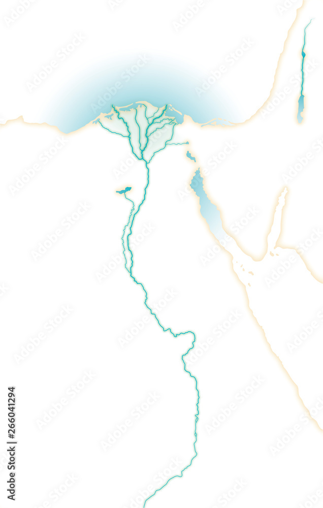
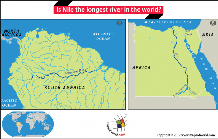
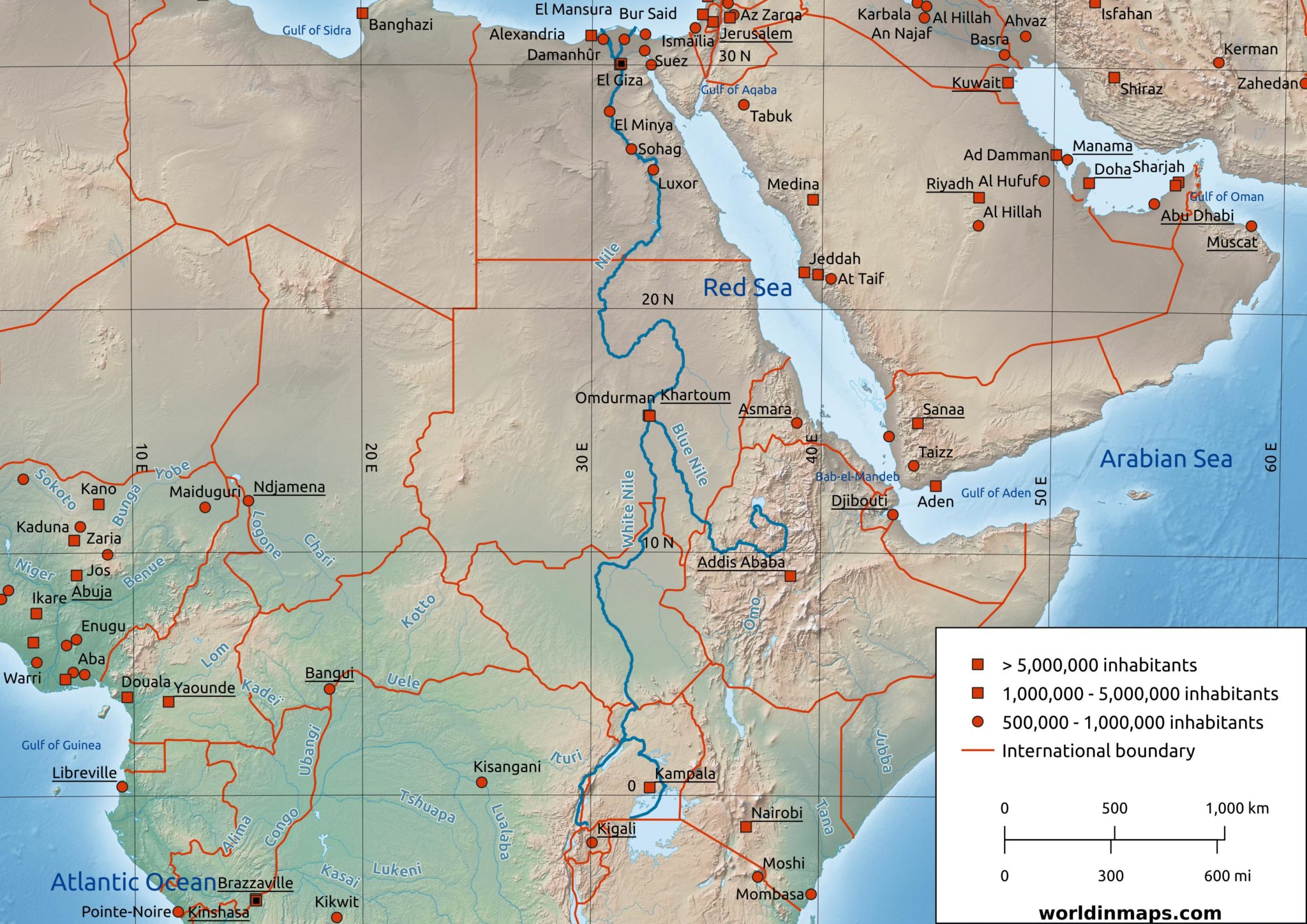
The Nile River, often regarded as the longest river in the world, stretches approximately 6,650 kilometers (4,132 miles). Its journey begins south of the equator and flows northward through northeastern Africa, eventually draining into the Mediterranean Sea. Understanding its trajectory on a map of Africa reveals the river's critical role in shaping the landscapes and livelihoods of numerous countries.
 Caption: The Nile River, a vital waterway, cuts through the heart of Africa.
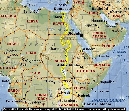
Tracing the Nile River on the Map of Africa: Key Countries
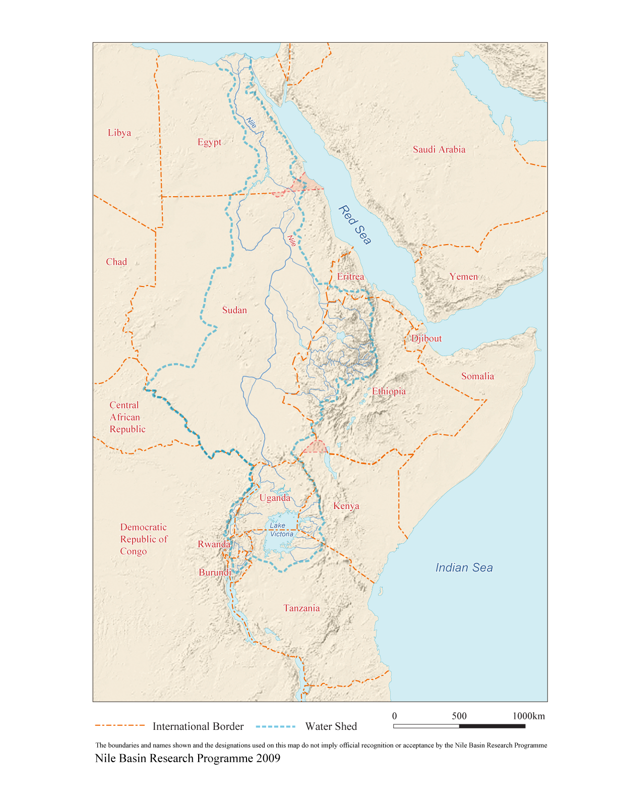
The Nile River and its tributaries traverse or border eleven countries, including:
- Uganda: One of the primary sources of the White Nile.
- South Sudan: Where the White Nile flows through vast swamps.
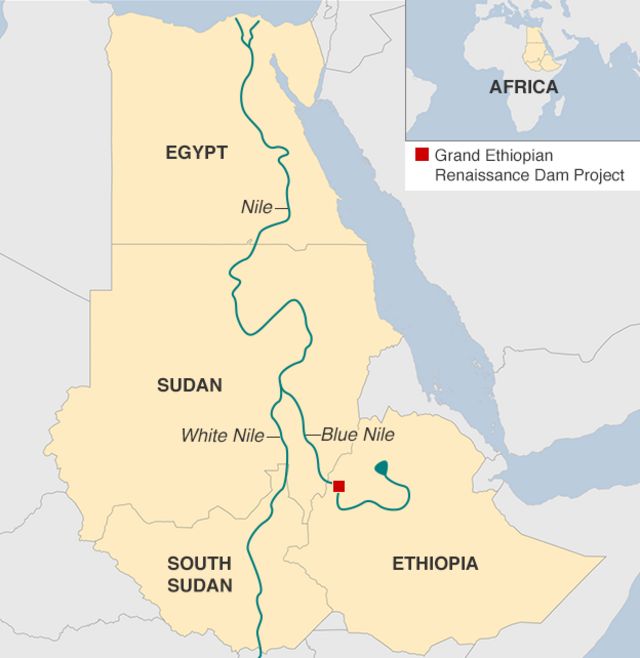
- Sudan: The convergence point of the White and Blue Nile.
- Egypt: Heavily reliant on the Nile for agriculture and water supply.
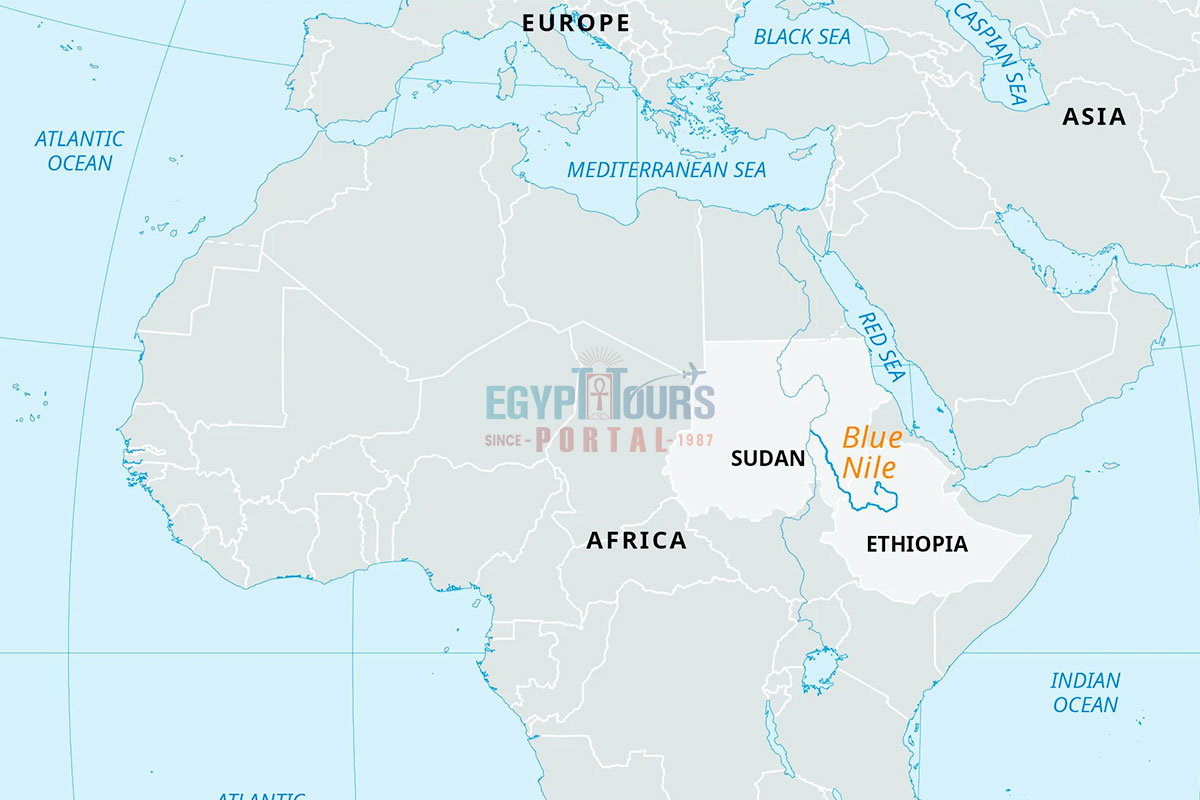
- Ethiopia: The source of the Blue Nile, contributing the majority of the Nile's water.
- Kenya, Tanzania, Rwanda, Burundi, Eritrea, and the Democratic Republic of Congo: Contribute to the Nile basin, albeit indirectly.
Visually tracing this journey on the map of Africa highlights the Nile's transboundary nature, making cooperative water management crucial.
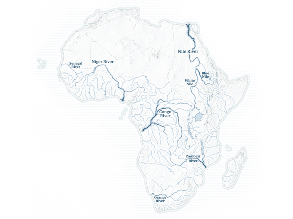
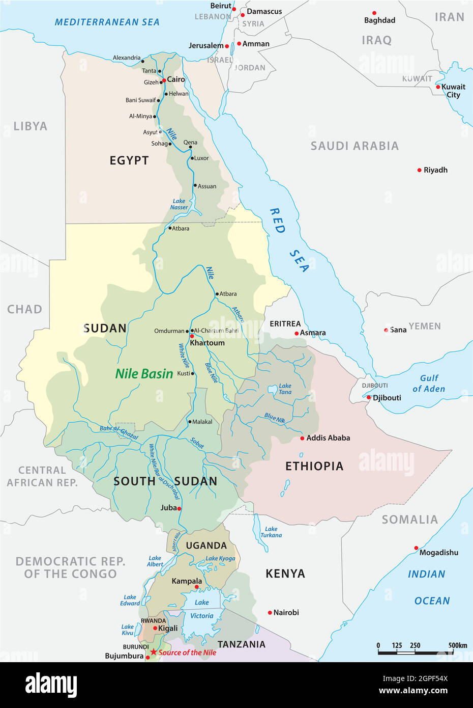
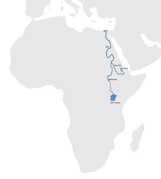
The White Nile and Blue Nile: Two Branches on the Map of Africa
The Nile is formed by two major tributaries: the White Nile and the Blue Nile. Understanding their origins on the map of Africa is essential.
- White Nile: Considered the longer of the two branches, the White Nile originates in the Great Lakes region of Central Africa, with its remotest source often cited as the Kagera River in Rwanda or Burundi, flowing into Lake Victoria and then northward.
- Blue Nile: The Blue Nile originates in Lake Tana in Ethiopia. It contributes the vast majority of the Nile's water and silt, especially during the rainy season.
The confluence of these two rivers occurs in Khartoum, the capital of Sudan, marking the beginning of the "Nile" as it is commonly known.
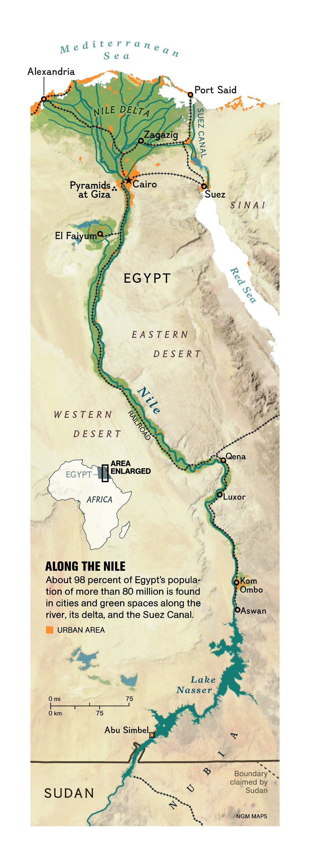
Historical Significance of the Nile River on the Map of Africa
The Nile's influence on the map of Africa is profound, particularly concerning ancient Egypt.
- Ancient Egypt: The Nile was the lifeblood of ancient Egyptian civilization. The annual flooding of the Nile deposited fertile silt, enabling highly productive agriculture. This surplus allowed for the development of a complex society, including monumental architecture (pyramids, temples), writing, and advanced governance. The Nile facilitated transportation and communication, connecting different parts of the kingdom.
- Trade and Navigation: The Nile served as a vital trade route, connecting communities along its banks and facilitating the exchange of goods and ideas. Ancient Egyptians navigated the Nile using boats, enabling them to explore, trade, and control vast territories.
- Religious Significance: The Nile held immense religious significance in ancient Egyptian mythology. It was associated with gods like Hapi, the god of the Nile flood, and Osiris, the god of the afterlife, whose story was intricately linked to the river's cycles.
Studying historical maps of the region reveals the concentration of settlements and agricultural lands along the Nile's banks, underscoring its pivotal role in shaping the cultural and political landscape of ancient Egypt.
Ecological Importance of the Nile River on the Map of Africa
The Nile River supports a rich diversity of ecosystems, playing a crucial role in the ecology of northeastern Africa.
- Biodiversity Hotspot: The Nile and its surrounding wetlands provide habitat for a wide variety of flora and fauna, including fish, birds, reptiles, and mammals. The Sudd swamps in South Sudan, a vast wetland area fed by the White Nile, are particularly important for biodiversity conservation.
- Water Source: The Nile is a critical water source for millions of people and livestock. It supports agriculture, industry, and domestic use in the countries through which it flows.
- Challenges: The Nile faces numerous environmental challenges, including pollution, over-extraction of water, and the impacts of climate change. These challenges threaten the river's ecological integrity and the livelihoods of communities that depend on it.
On a map of Africa, observing the green corridors along the Nile, representing vegetated areas and agricultural lands, highlights the river's importance for sustaining life in an otherwise arid region.
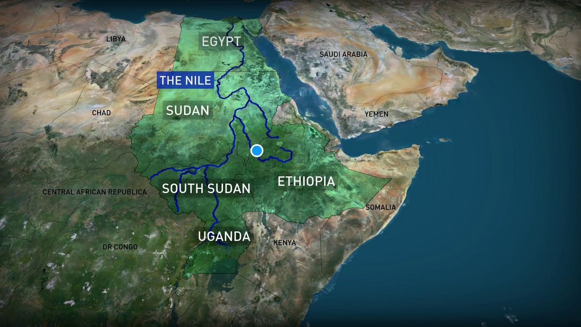
Modern Challenges and the Nile River on the Map of Africa
Today, the Nile River faces significant challenges, primarily related to water scarcity and regional tensions.
- The Grand Ethiopian Renaissance Dam (GERD): The construction of the GERD on the Blue Nile in Ethiopia has raised concerns among downstream countries, particularly Egypt and Sudan, regarding water availability and potential impacts on agriculture. This dam, though designed to generate hydroelectric power, highlights the complex geopolitical dynamics surrounding the Nile.
- Climate Change: Climate change is exacerbating water scarcity in the Nile basin, with rising temperatures and altered rainfall patterns affecting river flow and water availability.
- Water Management: Sustainable water management practices are essential to ensure the equitable and sustainable use of the Nile's resources. This requires cooperation among all Nile basin countries, taking into account the needs of all stakeholders and the long-term health of the river ecosystem.
Analyzing current maps of Africa showing infrastructure projects, population densities, and agricultural areas helps to understand the complex interplay of factors affecting the Nile's future.
Future of the Nile River on the Map of Africa
The future of the Nile River depends on cooperative water management and sustainable development practices.
- Regional Cooperation: Strengthening regional cooperation among Nile basin countries is essential to address water scarcity and ensure the equitable use of the river's resources.
- Sustainable Development: Promoting sustainable agricultural practices, investing in water-efficient technologies, and protecting the river's ecosystem are crucial for ensuring the long-term health of the Nile.
- Monitoring and Research: Continuous monitoring of the Nile's water quality and quantity, as well as research on the impacts of climate change, are essential for informing effective water management strategies.
By studying the map of Africa and understanding the Nile's complexities, we can work towards a future where the river continues to be a source of life and prosperity for all.
Question and Answer about Nile River on the Map of Africa
Q: Where does the Nile River start? A: The Nile River has two main sources: the White Nile, originating in the Great Lakes region of Central Africa, and the Blue Nile, originating in Lake Tana in Ethiopia.
Q: Which countries does the Nile River flow through? A: The Nile River and its tributaries flow through or border eleven countries: Uganda, South Sudan, Sudan, Egypt, Ethiopia, Kenya, Tanzania, Rwanda, Burundi, Eritrea, and the Democratic Republic of Congo.
Q: Why is the Nile River important? A: The Nile River is crucial for providing water, supporting agriculture, facilitating transportation, and sustaining ecosystems in northeastern Africa. It also played a vital role in the development of ancient Egyptian civilization.
Q: What are the challenges facing the Nile River today? A: The Nile River faces challenges such as water scarcity, pollution, the impacts of climate change, and regional tensions related to water management.
Q: What is the Grand Ethiopian Renaissance Dam (GERD)? A: The GERD is a large dam built on the Blue Nile in Ethiopia, designed to generate hydroelectric power. It has raised concerns among downstream countries, particularly Egypt and Sudan, regarding water availability.
Summary: The Nile River is a vital waterway on the map of Africa, crucial for geography, history, and ecology. Its sources are in central Africa and Ethiopia, flowing through multiple countries, especially important in ancient Egypt, and faces modern challenges like the GERD and climate change. The key to its future lies in regional cooperation and sustainable water management.
Keywords: Nile River, Map of Africa, White Nile, Blue Nile, Egypt, Ethiopia, Sudan, GERD, Water Management, Ancient Egypt, River Nile.


/559px-River_Nile_map.svg-5895b9ba3df78caebca37089.png)


Nile River Word Search Nile River Sources Egypt Tours Portal River Nile Map Stock Vector Nile River History Lesson Maps M S R Skenderiye Nil Nehri Tarih Haritalar Osmanl 2217301053 Nile River Map Of Africa Ae36a799f554da45d64c57b33c2e71cc Nile River In Egypt Best Things To Know In 2025 The Nile River In Africa Nile River Map Of Africa Vector Map Of The Nile River Basin 2GPF54X Africa Nile River Map 1000 F 266041294 AdXrhXTToL8WZnE5er1J6Pt6U9YfTwIU Africa Map With Nile River 81849043 Ethiopian Dam 624
Nile River Map Map 5C11 EN Medium 3x Nile River Map Printable Labeled Nile River On Africa Map Printable Image 135 Nile River Map Africa Stock Vector Ancient Egypt Map With Important Sights On The Nile River 1664066971 Map Of Africa Nile River Map Light@4x 100 Africa Nile River Map A Map Showing The Nile Basin And The Study Area B ITCZ Position In Summer And Winter Map Of Africa Nile River A327c175609f0a2bdbdc8f8badaa06d7 Africa Nile River Map MediaNile World In Maps Nile River Map 2048x1448
Africa Map With Rivers Labeled B7a4dd575e5bd07af28dbbb8371d1574 Map Of Africa Nile River Contention In Africa Map Of Africa Nile River Locator V2 Mobile Nile River On Map Of Africa Map Map Showing The Nile River With Its Main Branches White And Blue Niles And The Site Of Nile River Map Africa Africa Nile River Map Africa Nile River Map Nile And Delta Nile River On Map Of Africa Map Fbf75bfbec00745e523cebbb6f1abcaa
Africa Nile River Map Is Nile The Longest River 700x447 Nile River Africa Map 4780ca5c0fad1abb59292540e18e070c Africa Nile River Map Nile Basinc Interesting Facts About The Nile River For Kids 2024 Updated Nile River Map Nile River Map Of Africa Map 559px River Nile Map.svg 5895b9ba3df78caebca37089 Blue Nile River Africa Map Nile Rivers White Blue Ethiopia Rivers Of Africa Map Africa Rivres 1024x768
Nile River Map Of Africa Vlcsnap 2018 06 22 14h24m53s599 6 Br Nile World In Maps Nile River Satellite Map Scaled Nile River Africa Map 360 F 745257735 Sfxt0bxSgj6ZOVFa9GZEVdCLi7qrhA6c